Diamonds in the Rough - Tom Macaulay's Map Collection
By Heidi Sproat
Sometimes you just get lucky. Seems the Truckee-Donner Historical Society is very fortunate to have been the recipient of an absolute treasure trove of 63 new books, many now out of print and no longer available, over 250 maps, documents, reports, photographs, and aerial imagery from “Reno Iceman” himself, Thomas Macaulay. Although he passed away in 2020, he bequeathed his extensive historical collection to the Society.
Thomas Roderic Macaulay was a veteran of the navy in WWII, an outdoorsman, hunter, Eagle Scout and leader of Boy Scouts, an iron worker, glazier, engineer of 20 years at Sierra Pacific Power Company, home builder, and knowledgeable historian and researcher affectionately known as the “Reno Iceman.” Tom graduated from the University of Nevada, earning B.S. degrees in Electrical and Civil Engineering and a Masters in Civil Engineering. Tom was a major contributor to the iconic 1981 book about Truckee, Fire & Ice.
Carrying on the family tradition in the ice harvesting business, Tom’s grandfather (McCauley) was an ice harvester himself in the Truckee River Canyon and helped to start the ice houses along the Truckee River, specifically, the Summit Ice Company (1972-1920). Although the Summit business started its first operation on Donner Summit, it was later relocated to Prosser Creek – because it was colder there and less snow than on Donner Summit. (Gordon Richards 2004 article)(Susan Lindstrom’s 2017 report, Truckee River Revitalization Assessment Town River Corridor, Truckee).
Our expert ‘Reno Iceman’ helped us to better understand the industry, its tools, workers, and processes. Tom’s countless images of ice harvesting operations are unequalled.
Little did we know just how many “gems” we’d find in the voluminous material, at times overwhelming. Given Tom’s photographic knowledge of the ice industry and the Truckee River Canyon in particular, the Society has expended countless hours attempting to sort out his books, historical records, images, and map collection.
Well over 300 maps were found in Tom’s materials, many rubber-band bound, some in cardboard tubes – some not - and haphazardly moved unceremoniously in moving boxes. Most of the maps concentrate on the Truckee River Canyon in Nevada County and specifically, the ice industry. Contiguous Placer and Sierra counties are also peripherally related. The maps however generally cover the area from Soda Springs to Reno, with particular emphasis on Truckee, Martis Creek, Boca, Floriston, Farad, and Verdi.
Tom had at least twenty aerial images (so far) in his map collection spanning from the 1940s to the 1970s. He also assembled composites of aerial images and using US Geological Survey maps, and identified on the aerial maps many of the mountains, peaks, rivers, valleys, creeks, reservoirs, towns, dams, camps, and CPRR stations. Priceless. He also obtained hundreds of maps which identified real estate ownership and right of way grants, most in the early 1900s.
Here are just a few of the “diamonds” we found.
* Truckee Map noting 208 mile marker from San Francisco
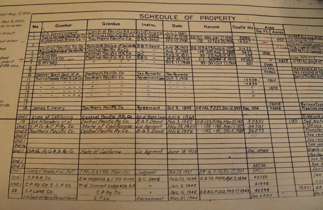
* Schedule of Property showing July 1, 1862 Act of Congress US Government land grant to CPRR - way cool
* Eder and Donner Railroad stations - no longer there
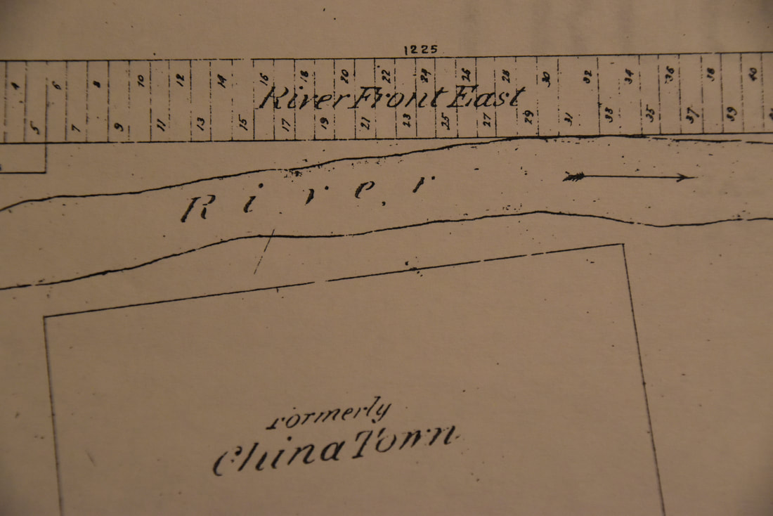
* 1901 Truckee Waggoner survey map showing "formerly ChinaTown" and a Pythian Temple building across from the Roadmaster's House – a “temple”
* Map showing eastern-bound next size city is "Ogden", not Sparks, Wadsworth or other; western bound city is San Francisco
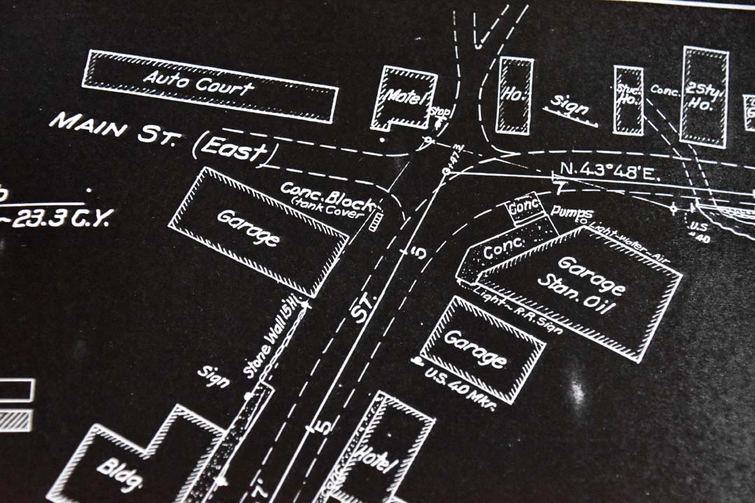
* Truckee 1924 map shows "Main Street" with Auto Court and Motel
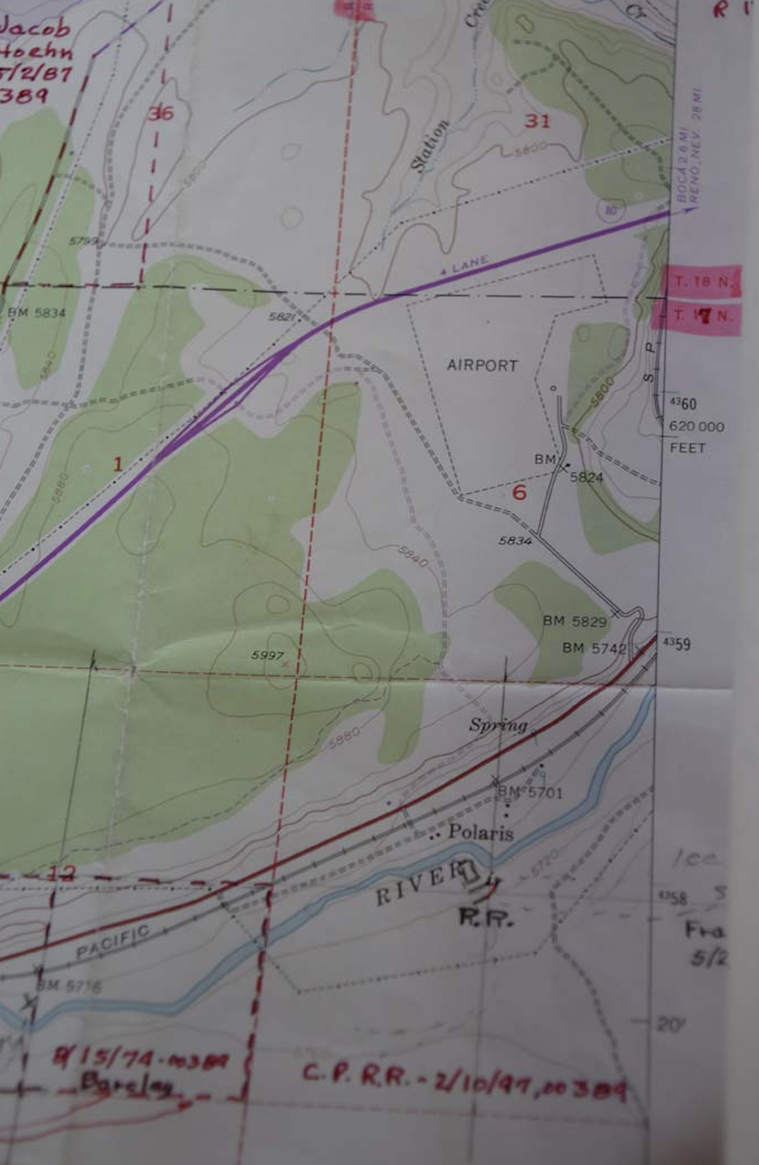
* 1955 Truckee Quadrangle map showing "L" outline of OLD airport
While the maps are not digitized, the Society has spent countless volunteer hours collating and indexing salient points on the maps so that they can be searched by topic, issuer, date (most of them are undated, but many are from the early 1900s), property owner, or salient geological formation. For example, we had never seen an official drawing that had the Eder station marked on it, although google maps mark it. We found only a few early maps that even show Eder (TMC M0001 Index, p.14; M0040). We have also repeatedly read that Truckee was considered the most developed town on the Central Pacific Railroad line heading east over the crest of the Sierras. It wasn’t Reno, Sparks, Wadsworth or some other town, but Ogden, Utah. Early maps confirm this.
But for me, seeing on paper that the Grantor, U.S. Government granted to the Central Pacific Railroad Co. by July 1, 1862 Act of Congress was telling. We’ve heard this for so many years but this is the first time I saw it formalized in writing on map after map of the CPRR line.
While we also knew the general location of the old Truckee airport, a 1955 USGS Truckee Quadrangle map confirmed that the airport was in the shape of an “L”. The Tahoe Truckee Airport has a photograph that even shows airplanes parked on one of the “runways.”
And most unexpectedly, and the true ‘diamond,’ we found an original 1942 map by the Division of Forest Survey identifying the location of mills then still existing, closed, and flumes in the Truckee River basin. We have been looking for this map of the Lumbering History of the Truckee River Basin 1856-1936 report for years. Voila!
If you want to take a peek at some of these historical maps, we have them in the Joseph Research Library Cabin in Meadow Park for review on most Thursdays between 10 am and 2 pm. If you are looking for something in particular, or just want to browse some of these historic maps which go back to the late 1800s, stop on in. And if you’re looking for reference to a specific place like Eder, Goulden Station, Tunnel 14, Banner Mill (M0134) Camp 16 or Camp 20 (Cuba) (link) (Summit Ice Co.) (People’s Ice Co. at Camp 20), these maps are a goldmine. Want to know where the Crown Willamette Paper Company was located, or the Boca and Loyalton Railroad line, or the Lake Tahoe Railway & Transportation Company line merge in Truckee, foot bridges or wagon roads, Truckee’s rail line “balloon track” (M0052), Richardson Bros. property, the location of the Pacific Fruit Express property, Steamboat Dam, T.C. Wohlbruck’s “canteen” (M0096), the “old airport” or airway beacons (M0166), and so much more, then these maps will surely help to answer your questions. For example, I had never even heard of Uhlen Lake, which is northeast of Lake Van Norden in Placer County (M0062, M0070).
We are very fortunate indeed to have been the recipient of so many ‘diamonds in the rough.’ Now we just have to continue to carve out volunteer time to dive in indexing and cataloging all the hundreds of reports, documents, and images. If this sounds like something that would interest you, and you would like to assist us and in the process learn more about our beloved Truckee history, please get in touch with us at [email protected] . Oh, do we have an opportunity for you!
|
HCS 7/23/2022
|
Editor's Note: So if you're trying to find some reference to a specific place, business, or geographic site, you might find it useful to start searching in THIS Index to Tom Macaulay's Map Collection. Our current scanning capabilities do not at present allow you to search for specific references, so this Index may assist you in your searching. For example, if you wanted so see WHICH maps of Tom Macaulay refer to Trout Creek, try searching in the index first. The corresponding TMC Mxxx map number on the far left of the index will direct you to the appropriate map with that search term. Take note of the map number, the box number, and size of the item in order to expedite locating it in our Map Collection at the Joseph Research Library Cabin.
Note: Box 1 = TMC M0001 - TMC M0043, rolls of maps/drawings in large rectangular box marked Box 1
FLAT Box 2 (back room top cabinet shelf) = TMC 0044 - TMC M0123 ;
and Box 3 = TMC M0124 - TMC M0171.
Note: Box 1 = TMC M0001 - TMC M0043, rolls of maps/drawings in large rectangular box marked Box 1
FLAT Box 2 (back room top cabinet shelf) = TMC 0044 - TMC M0123 ;
and Box 3 = TMC M0124 - TMC M0171.
Index updated HCS 11/9/2023.


