Surprises in the National Archives - You've Got Mail!
Post Office Discoveries
By Heidi Sproat
Sometimes when you’re just doing research on one topic, something else catches your eye. This is exactly what happened when I was reviewing articles for a colleague about Polaris and Iceland. Seems the National Archives has an entire section about Post Offices that were approved across the United States from 1837 - 1950. Who knew? Frankly, who cares you say? The records are supposedly organized by state, then county, then alphabetically - almost. Naturally, living in Truckee in Nevada County, I wanted to see which areas had post offices and the dates when they were approved. Reviewing Nevada County, California, which was formed on April 25th, 1851, I found approximately 52 post offices in Nevada County in this compilation. Do not confuse the State of Nevada founding in October 1864, some 13 years AFTER Nevada County, CA.
Although these post office records are archaic by today’s standards, many of the post office sites are long gone. Why? After the ’49-er California Gold rush quieted down, the railroad was completed, timber harvesting and logging operations had scalped the forest, Comstock Mining evaporated, and the local ice industry succumbed to mechanical refrigeration, only “select” towns survived, and their post offices remained intact.
Why would anyone care about looking at applications for post offices in the late 1800s and early 1900s? One of the biggest reasons is to review the submissions for those extraneous notes and maps, albeit crude, which help to refine the location of the proposed post offices. Comments one can pick up on are invaluable to understand the development of the area.
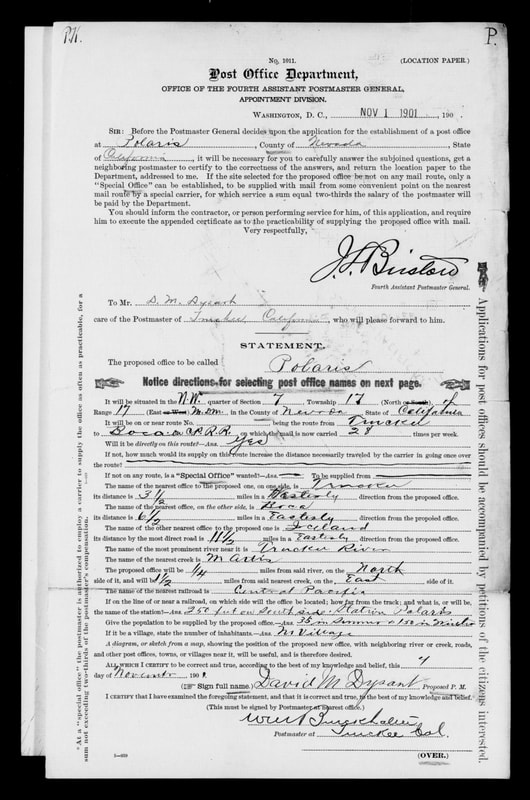
Recall Truckee became Truckee all because of the Railroad. So naturally, post office stations developed first on this route. Revelations in these applications include expected population to be served, and if there was a difference between summer and winter, as was, for example, the case of Polaris (proposed postmaster David M. Dysart, and signed by the Postmaster at the nearest office, Truckee, Wm. Burckhalter).
The most interesting forms I found were for places I’ve never heard of: Anthony House (p. 750), Blue Tent (p. 758), Cedar Ridge (p. 773), Elida (p. 787), Gaston (p. 806), Mountain Well (p. 919), and Wolf (p. 9, 1887, p. 3-15, 1004). Of all the humorous names, You Bet (p. 3, 1867, and p. 1012, 1877) takes the prize. Of course I’d heard of the place before, but I’d never seen anything about post offices in print. Another great name, Rough and Ready (pp. 65 1877; 946, re-established 1947).
The Post Offices along the Truckee River Canyon were expected because the railroad ran through it: Boca (p. 760), Bronco (p. 768, 1877), Floriston (1937, p. 793, formerly Bronco p. 795), Iceland (1897, p. 834), Polaris (1901, p. 939), and of course Truckee (1867; 1898, p. 984). What was so eye popping about Truckee was the date December 19, 1867. Recall the Central Pacific Railroad was not completed until 1868, and even as late as Aug. 4, 1937, Truckee was in Meadow Lake Township.
The Post Offices along the Truckee River Canyon were expected because the railroad ran through it: Boca (p. 760), Bronco (p. 768, 1877), Floriston (1937, p. 793, formerly Bronco p. 795), Iceland (1897, p. 834), Polaris (1901, p. 939), and of course Truckee (1867; 1898, p. 984). What was so eye popping about Truckee was the date December 19, 1867. Recall the Central Pacific Railroad was not completed until 1868, and even as late as Aug. 4, 1937, Truckee was in Meadow Lake Township.
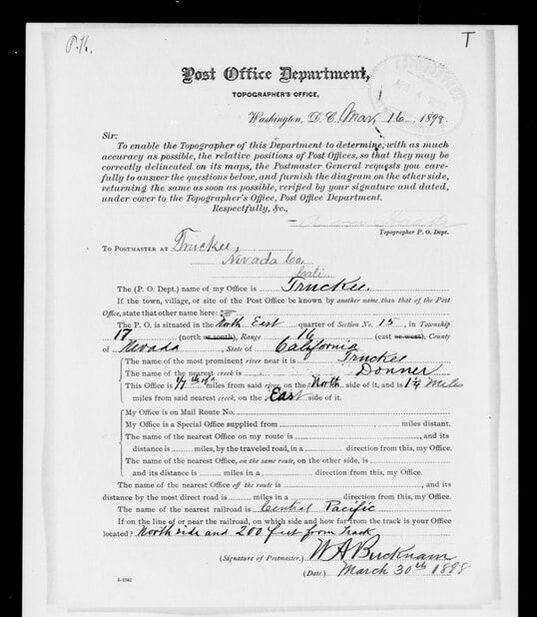
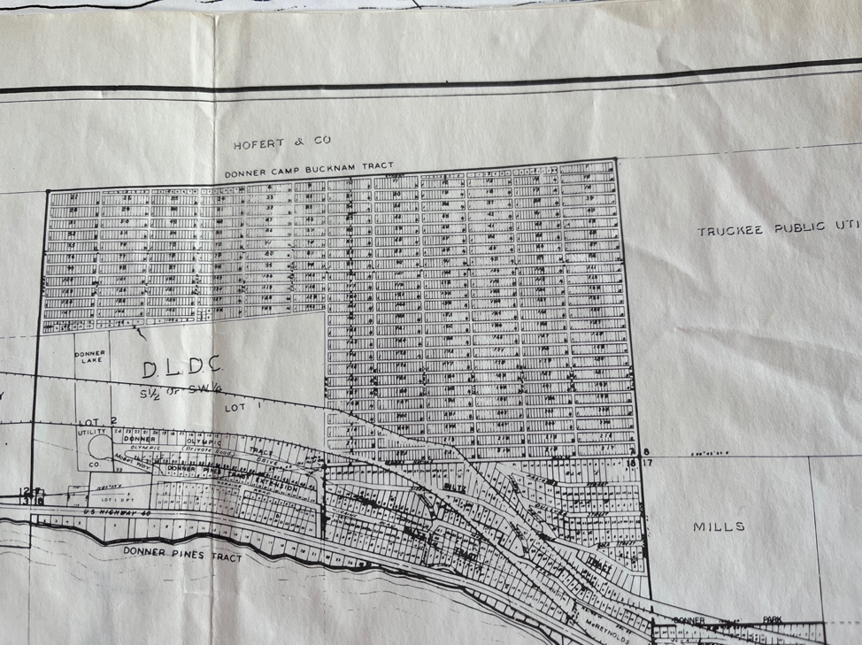
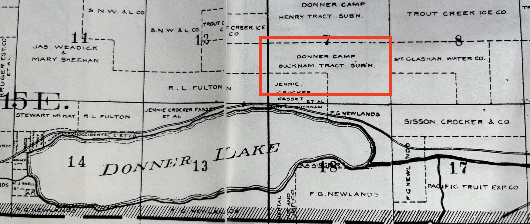
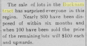
Curiously, the March 30, 1898 submission was signed by William A. Bucknam – of the same “Bucknam Tract” just north of I80 and west of Northwoods. Bucknam Tract was a conglomeration of hundreds of postage size 20’ by 80’ lots on very steep slopes. Cdnc.ucr.edu The Tract was laid out in 1911 after the San Francisco earthquake and boasted temporary housing if another earthquake occurred. Problem with this was there were no roads and properties were literally bunched together and inaccessible individually. Map. Donner Camp Bucknam Tract.
To get a better idea of exactly WHERE the Bucknam Tract was, this map excerpt, circa 1913, shows the location relative to Donner Lake.
A short excerpt from an article in the Truckee Republican on September 27, 1911 reflects the sale of these lots:
I also learned from newspaper clippings that this same W.A. Bucknam was mentioned as superintendent of the Champion Ice Co., and at one point, Secretary. How about that find!
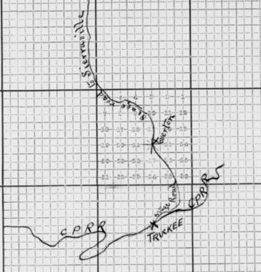
Expectedly, most post office locations are identified by the Mt. Diablo point of reference and the Tahoe National Forest (“TNF”) grid position. Interestingly enough, a sketch map usually accompanied each submission. Clearly, the submitters were NOT the best map makers, but they are telling. There is even a notation about the path of a stage route to Overton in Hobart Mills (1900).
Expectedly, most post office locations are identified by the Mt. Diablo point of reference and the Tahoe National Forest (“TNF”) grid position. Interestingly enough, a sketch map usually accompanied each submission. Clearly, the submitters were NOT the best map makers, but they are telling. There is even a notation about the path of a stage route to Overton in Hobart Mills (1900).
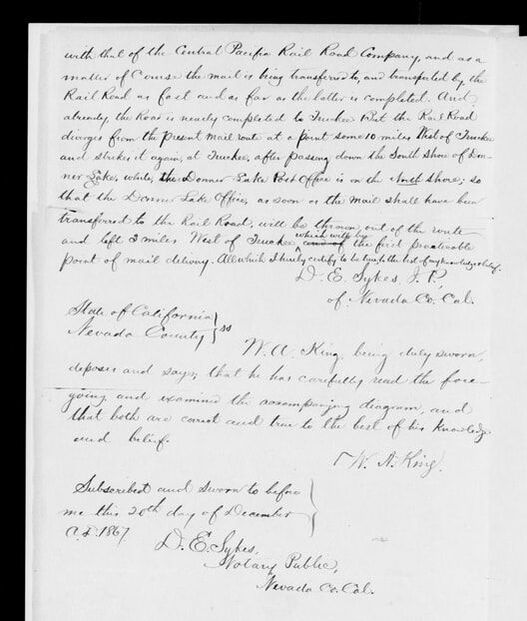
The submitter also included an explanation with this 1867 Truckee application:
“It should be further stated, in the connection, that the interest of the Pioneer Company, now carrying the mail on this route, is identical with that of the Central Pacific Rail Road Company, and as a matter of course the mail is being transferred to, and transported by, the Rail Road as fast and as far as the latter is completed. And already, the Road is nearly completed to Truckee. But the Rail Road diverges from the present mail route at a point some 10 miles West of Truckee and strikes it again, at Truckee, after passing down the South Shore of Donner Lake, while, the Donner Lake Post Office is on the South Shore; so that the Donner Lake Office, as soon as the mail shall have been transferred to the Rail Road, will be thrown out of the route and left 2 miles West of Truckee which will be the first practicable point of mail delivery. All which I hereby certify to be true to the best of my knowledge and belief. /s/ D.E. Sykes, J.P.“ (Emphasis added.)”
“It should be further stated, in the connection, that the interest of the Pioneer Company, now carrying the mail on this route, is identical with that of the Central Pacific Rail Road Company, and as a matter of course the mail is being transferred to, and transported by, the Rail Road as fast and as far as the latter is completed. And already, the Road is nearly completed to Truckee. But the Rail Road diverges from the present mail route at a point some 10 miles West of Truckee and strikes it again, at Truckee, after passing down the South Shore of Donner Lake, while, the Donner Lake Post Office is on the South Shore; so that the Donner Lake Office, as soon as the mail shall have been transferred to the Rail Road, will be thrown out of the route and left 2 miles West of Truckee which will be the first practicable point of mail delivery. All which I hereby certify to be true to the best of my knowledge and belief. /s/ D.E. Sykes, J.P.“ (Emphasis added.)”
So let me envision this statement: “will be thrown out of the route and left 2 miles West of Truckee”. Does this actually mean mailbags were thrown from the Central Pacific Rail Road Trains and retrieved for delivery? I’m open for suggestions.
Hobart Mills (1900) was also familiar, as was Gelatt. Another surprise was Norden station was known by another name, Donner, and someone wrote on the form, name changed 9/26 – that is 1926. This was signed by a “Thrift Baker, Ass’t Postmaster June 28th, 1926.” In this case, the post office building would be on the NORTH side of the Southern Pacific Railroad and at a distance of 1,033 feet from the station. The railroad station name is Norden.
Crude, but very effective hand drawn maps are revealing.
Another surprise was that Donner, in Placer County, had yet another name for this station – Summit. But this form says there was a name change to Norden. Confusing? You Bet-cha (no pun intended.) (pages 3-7, 12/13/1867, You Bet). Summit Valley was also crossed out and Soda Springs (local name Tinker’s Station) put in its place in this Dec. 20, 1870 contract, signed by J. A. Tinker himself. It was signed by none other than J.A. Tinker himself, Dec. 20th, 1870. Tinker noted that there was no other office within 50 miles of this route (probably half true based on these other applications for neighboring post offices).
Besides the detail about the station name and location, there are other questions asked about the name of the nearest river, nearest creek, nearest office on route, distance in miles, direction, whether the post office building was located on the north or south side of the Southern Pacific Railroad and the distance in feet from the track, and in some cases, the intended population that would be serviced by the post office. Notably, Iceland shows it would serve a population of 75, and is on the San Francisco – Ogden route. Note, it did not say San Francisco to Reno, Wadsworth or some other State of Nevada city route, but Ogden. [I also noted that some Placer County post offices also refer to the San Francisco – Ogden line, notably Hotaling. (See footnote about Hotaling]. Also, on the Iceland form, the name of the station would be Cuba, signed by Mary Dysart, wife of the superintendent of the local Polaris ice harvesting business. Polaris’ Post Office 1901 forms reveal a summer population of 35, but a winter population of 150. Surely ice harvesting would account for the fourfold increase in population.
Other Nevada County Post Offices included in this collection include Washington (pp. 17- 23), Tyler (formerly Patterson, also Melrose, p. 30), Sweetland (Nevada City to Downieville; this is the second earliest date I saw, 1857), Spenceville, Relief, Red Dog (the earliest I saw in 1855), Buena Vista (crossed out and Peardale entered), Painesville (1863), Omega (1873), Mountain Well (1858), and several others. If you’re interested, or curious, there are over 1,000 pages in this collection. Maybe something will “jump out at you” as it did me – Bucknam, Tinker’s Station, San Francisco to Ogden route.
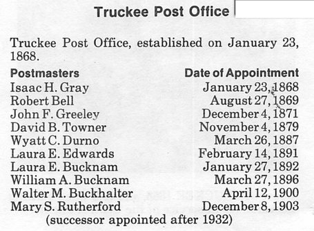
Browsing through the Nevada County Historical Society Bulletin issues, I happened upon a listing of the Postmasters/Postmistresses of Truckee. Notice that there are two Bucknams listed.
Based on the United States Postal Service records, the remaining post offices in Nevada County today number nine (9) and include Cedar Ridge (95924), Chicago Park (95712), Grass Valley (95945), Nevada City (95959) the oldest post office established in 1850, North San Juan (95960), Rough and Ready (95975), Soda Springs (95728), Truckee (96161), and Washington (95986). Obviously back then there was no such thing as "zip codes."
I’ve learned that if you really want to get to know more about the history of the area, you have to dig into records that were produced at the time. Records like these and census records that are more routinely being placed online for geeks like me to search through them can be goldmines of information.
Here’s another example of what you might find when you’re looking for something else. Also in the National Archives are over 2,900 posters that were popular in World War II.
So if you ever dismiss taking that side road when you’re researching, think again. Staying on point can be very boring. Exploring new records can be an enlightening diversion.
_______________________________
HOTALING – In the 1850s, ranchers and farmers moved into this area located about five miles north of Auburn. As the village grew, a fine hotel, mail delivery station, and stagecoach stop were added. In 1880, the California Iron Company founded an iron ore smelting works here. Employees from the company built homes in the surrounding hills which had become known as HOTALING, after Richard M. Hotaling, the company owner. When the smeltery closed, however, Hotaling became just another name in the history books. http://genealogytrails.com/cal/placer/towns.html#HOTALING .
National Archives,
https://www.archives.gov/research/post-offices/locations-1837-1950.html
Genealogy Trail listed all Nevada County Post Offices and their operating years.
http://genealogytrails.com/cal/nv/postoffices.html
Tahoe Donner News, August 2013, pp. 22-24, McGlashan Springs and the Bucknam Tract, by Ben Levine,
https://issuu.com/tahoedonnernews/docs/tdnews_aug2013_webissuu.com/tahoedonnernews/docs/tdnews_aug2013_web
Also found neighboring Placer County post offices of Brockway, and a reference to “Steamboat?”, and Dutch Flat.
Author’s Note:
Since first discovering these Post Office records available at the National Archives, I have since discovered that the page numbering system is “off” of what it was when I initially prepared this article, so be wary of the referencing page numbers. The records are IN this Record Group 28, but you may have to search for them.
HCS 11/1/2023; updated 11/12/2023
