|
Updated and corrected HS 8/28/2019; 8/9/2021;
6/28/2022; 7/7/2022; 7/28/2022 Supplemental Content
Echoes From the Past December 2015 Issue 4 Donner Ridge Fire of 1960 In researching and preparing the article on the Donner Ridge Fire of 1960, we came across several incredible resources as well as some unbelievable images that we would like to share with you. Appropriate credit is rendered to each source. We also provide a list of research materials we consulted for the article which includes groups of source documents. |
Websites consulted:
- Google Maps; Sardine Valley; Stampede Dam & Reservoir not in place until 1970 – AFTER the Donner Ridge Fire of 1960 and does not appear on earlier maps
- Ignition Management Plan Battalion 15 Fire History
- Map showing various peaks in Nevada, Sierra, Washoe counties relative to the fire, including Verdi Peak lookout
- Karl Breckenridge wordpress blog
- KCRA's Stan Atkinson's "Black Harvest" aerial survey of fire; produced 1960; retrieved courtesy of the U.S. Forest Service and a thank you to the National Archives in College Park, Maryland (NARA) for providing a copy
- Reno Fire Fighters Local 731
- Summer of Defensible Space, Moonshine Ink, June 19, 2011, by David Bunker
- Google Books
- Sierra Sun article, 2010, the Donner Ridge Fire of 1960 - 50 years later
- Washoe Zephyrs
- Mark Twain, Roughing It, p. 160
- Historic Map Works for Nevada and Sierra Counties
- The Great Fire of 1910 - Idaho; same day August 20 - 50 years earlier
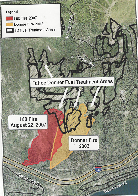
- Tahoe Donner News Fire Map showing 2003 and 2007 fire areas
- Numerous articles from Tahoe Daily Tribune, Nevada State Journal, Reno Evening Gazette, Chicago Tribune, The Union, Sierra Sun, Sierra Outsider, and Tahoe Donner News; we were also recently (June 2022) able to obtain a copy of the Reno Evening Gazette August 22, 1960 front page issue about the fire. Take a look.
- USGS Maps showing location of Negro Canyon (now Johnson Canyon); name changed in 1960s to Negro; in 1963, then Secretary of the Interior Stuart Udall ordered that certain derogatory place names on federal place maps be changed; hence the Canyon's name was changed to Negro
- Lady Fire Spotter at remote Verdi Peak from mid-June to mid-October; note the article was written just a year before the Donner Ridge Fire which burned toward Verdi Peak; and incredibly, it was this same female fire spotter, Mrs. Lane Endicott of Kings Beach and her daughter, who were rescued by airlift from the Verdi Peak Lookout out of the path of the Donner fire
- "Natural Reforestation in the Northern Sierra Nevada-Donner Ridge Burn," by Jane H. Bock and Carl E. Bock, Biology Department University of Colorado, Boulder, CO, 1969, Proceedings Tall Timbers Fire Ecology Conference 9:119-126, University of California Press
- An additional source of information about the 1960 Donner Ridge Fire was provided by a reader of Nextdoor, the neighborhood online forum. This is a great map of a history of all the fires in California:
https://projects.capradio.org/california-fire-history/#12.93/39.3256/-120.27742. Thank you to the Tahoe Donner poster.
Footnotes:
1, 3. It was not until 1971 when the Tahoe Donner land was developed by Jack Kirby as a family resort – DART - with numerous recreational facilities all in one place. Though marred by the Donner Ridge Fire in 1960, Kirby bought the 4,000 + acres of scarred land and hired a ski expert to determine whether a family ski area could be built in the burn area. The first home in Tahoe Donner was built in 1972 and the area consists of approximately 6,000 acres. Before the subdivision was built, there was general forest management. The area was heavily logged in the 1920s. There are 3,300 acres managed by Tahoe Donner Association of which 1,300 are interspersed among homes. Lake World was one of the original development names for this area.
2. See Wikipedia information about Washoe Zephyrs, and Mark Twain's Roughing It.
4. We tried diligently to obtain a copy of this documentary, but were unsuccessful in acquiring it.
5. Read more about the Great Fire of 1910 in Idaho and the story behind firefighter Pulaski.
6. Read more about how Tahoe Donner oversees its own Forestry Department and how fuel breaks, mastication, thinning and best practices management can help to mitigate fire's effects.
|
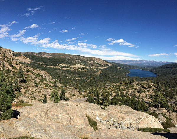
(Above) From a Google Image screen capture;
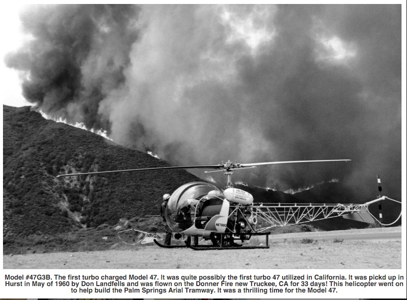
see also http://scottsbell47.com/gallery.html (Above) Retrieved and excerpted from
Tahoe Donner News; dated after 2007 Reprinted with permission from Tahoe Donner Association; aerial reprint originally published in
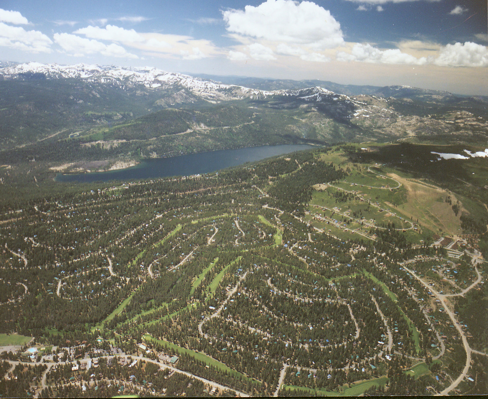
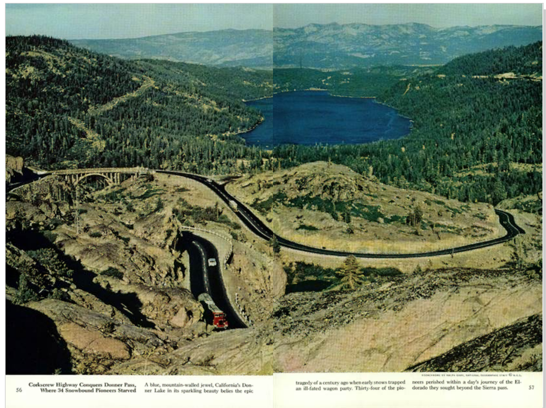
Tahoe Donner News, May 2006 This author stumbled upon this image of Donner Lake and surrounding area in a July 1961 National Geographic Magazine article, pp. 56-57, but this author believes this photograph was taken BEFORE the August 1960 Donner Ridge Fire.
Photograph included in article "From Sea to Shining Sea"; kodachrome by Ralph Gray, National Geographic Staff. Additional research assistance graciously
rendered by Ron Rettig. |
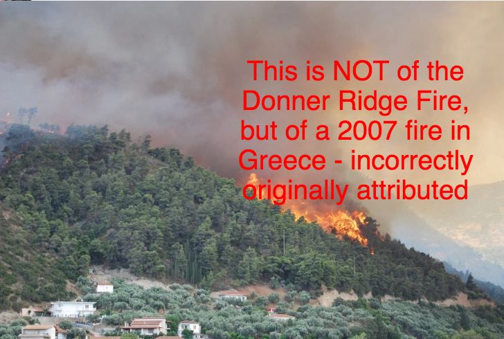
(Above) Incorrectly attributed to California Division of Forestry by author Karl Breckenridge in his article; further research indicates that this image is NOT of the 1960 Donner Ridge Fire but of a 2007 fire in Greece; thanks to the reader who noticed this and brought this to our attention
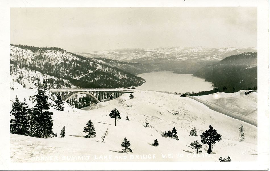
From a RPPC postcard postmarked dated February 25, 1960 just after the Squaw Valley Winter Olympics but before the Donner Ridge Fire of August 1960 - notice the abundant trees on the left just above the cut
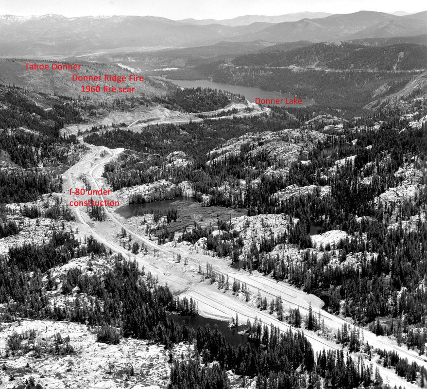
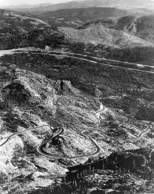
and compare the above image to this image below taken in 1962-1963 before Interstate 80 was completed - about 2 years
after the Donner Ridge fire; image courtesy of California Department of Public Works, Division of Highways (the precursor of today’s CalTrans) There is another high resolution aerial image available at the Sierra College website at this link, and the 1960 fire scar is very visible.
Highways for National Defense Advertisement, 1940. This appeared in a 1940 edition of California Highways and Public Works.
I-80, over the Donner Summit, September 24, 1964. Traversing over the difficult terrain of the Donner Summit. |
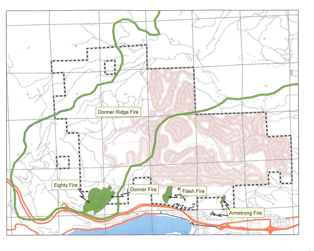
And courtesy of Bill Houdyschell, Forester at Tahoe Donner Association, below is a map which shows the "burn area" of the 1960 fire as it raced through Tahoe Donner, as well as other area fires.
Editor, Heidi Sproat - updated October 17, 2016; website link to Black Harvest updated August 28, 2019; 8/9/2021
Editor's Note #2 6/28/2022 HCS: In the original December 2015 , p. 7. article about the Donner Ridge fire, there was a reference to a Battalion 15 Fire History. That link has gone AWOL, but you can read it here from the wayback machine, web.archive.org/web/20161227042954/http://cdfdata.fire.ca.gov/pub/fireplan/fpupload/fpppdf1024.pdf
Another Editor's Note: HCS 7/28/2022
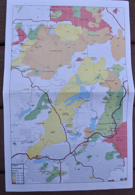
Courtesy of John Kennedy, retired forester, who obtained a fire map showing area fires from 1908 - 2020, a remarkable map. Provided courtesy of Linda Ferguson, Fuels Specialist, Forest Service, Tahoe National Forest Truckee Ranger District, www.fs.fed.us.
Courtesy of John Kennedy, retired forester, who obtained a fire map showing area fires from 1908 - 2020, a remarkable map. Provided courtesy of Linda Ferguson, Fuels Specialist, Forest Service, Tahoe National Forest Truckee Ranger District, www.fs.fed.us.
To view a much higher resolution .tif photo, 22 MB, click this link.
