History: The story of Trout Creek
By Judy DePuy
By Judy DePuy
Trout Creek is a small tributary of the Truckee River north of Lake Tahoe that originates from Tahoe Donner on the eastern Sierra Nevada, flowing southeast for approximately 5.5 miles, through downtown Truckee and then east to the Truckee River. The historic route of Trout Creek ran southeast through the center of town near Bridge Street.
In upper Trout Creek, glacial melting and retreating left a broad, eastward sloping outwash that then became forest and marsh. Approximately 90% of the Trout Creek watershed has been developed as part of the Tahoe Donner Community. However, much of the native high mountain evergreen forest has been retained, together with large areas of high alpine meadow that includes Bennett Flat meadow.
The lower portion of Trout Creek is another story.
Over the past 160 years, this section of the creek has been significantly impacted and modified due to adjacent land use activities, the development of downtown Truckee, the rail yard, the desire to reduce flood risk to the Town and adjacent properties, and to utilize the resource (water).
Impact to the Creek Started Early
Misuse of the creek started in 1863 when Joseph Gray built a way station at the foot of the Trout Creek watershed on the California Emigrant Trail. Elle Ellen arrived in Truckee in 1868, following in the heels of the Transcontinental Railroad. Ellen built his second saw mill three miles from Truckee along Trout Creek and operated it between 1876 and 1883.
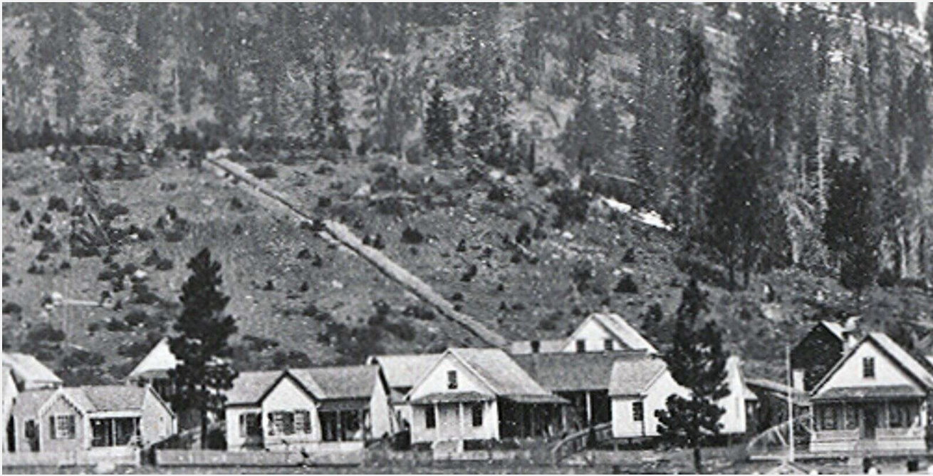
Ellen built the first logging flume in the area that was 3.5 miles long and obtained its water from Trout Creek. This manner of transporting the lumber was much more economical than pulling the logs down the hill using oxen and horses. The V-flume descended along the north and east side of Trout Creek from Ellen’s mill near Bennett Flat. Lumber floated down the V- flume which ran parallel to the creek and ended at the railroad. When water was low, he got water from the two large springs near his mill.
The 1885 USGS Quad Map for Truckee is the earliest record of Trout Creek. It shows the creek flowing in a southeasterly direction to where it meets with the Truckee River, right through present-day downtown Truckee (in the vicinity of Bridge and Church Streets). This route is considerably shorter and steeper than the current creek alignment through town.
By 1900, a map of downtown Truckee shows that Trout Creek had been diverted at Jibboom Street to a northeasterly flow path, probably to provide a water source for the Ice Pond also shown in the 1900 map. This allowed development of downtown Truckee to the east of Bridge Street. The creek was then connected (with much smaller drainage) to the Truckee River.
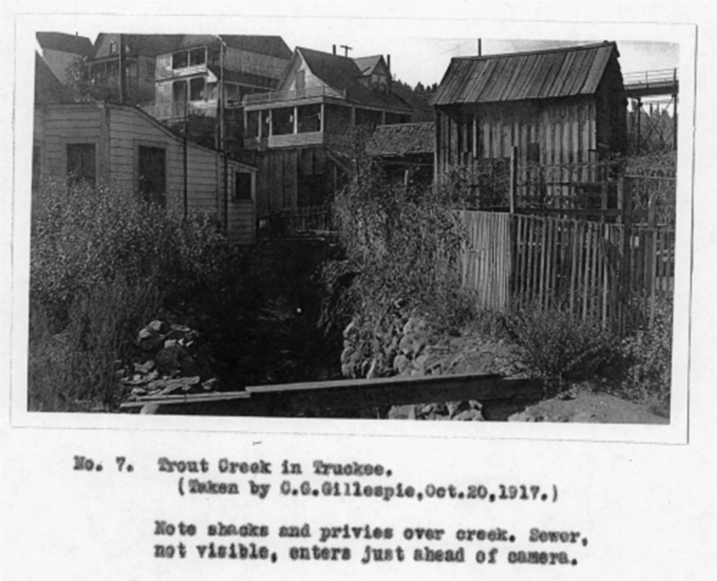
In 1903 Truckee had several major health emergencies with outbreaks of Scarlett Fever, Smallpox, Diptheria, Typhoid Fever and Influenza. Much of this was caused by the shacks and privies that ‘dumped’ into Trout Creek. The Truckee Republican reported on October 5, 1907:
“Considerable talk is also being made over the polluting of the waters of Trout Creek, so that it is nothing more than a sewerage ditch. This stream, which at this time of year is almost dry, has been filled with all sorts of rubbish, giving forth a stench which is obnoxious to the extreme.”
Trout Creek was considered the ideal breeding ground for many of the diseases that were plaguing Truckee. The pollution of Trout Creek and extreme health concerns led Truckee to form the Truckee Sanitary District in 1906. By 1909 they had installed 17,000 feet of sewer lines that served 110 buildings and two cesspools in Truckee.
As late as 1917, privies still hung over the creek. By 1918 there was a report by the State Board of Health regarding the feasibility of cleaning up Trout Creek.
From the 1930s to 1945 garbage was dumped from Euer Valley Road down the east flank of Trout Creek. The Trout Creek Dump was the first organized garbage collection in the town’s history. During the 1940s and 1950s there were a number of “hobo camps” along Trout Creek where the transients may have contributed refuse to the Trout Creek dump.
Changing the Creek
Lower Trout Creek has been highly disturbed with much of the creek’s channel having been rerouted and channelized. As a result the creek channel has been unstable, requiring on-going maintenance. Between 1952 and 1966, significant changes occurred on lower Trout Creek with the creek being placed to its current location. Major events included the completion of Interstate 80 in 1964 and Bridge Street being extended thus resulting in the straightening of Trout Creek down to Jibboom Street.
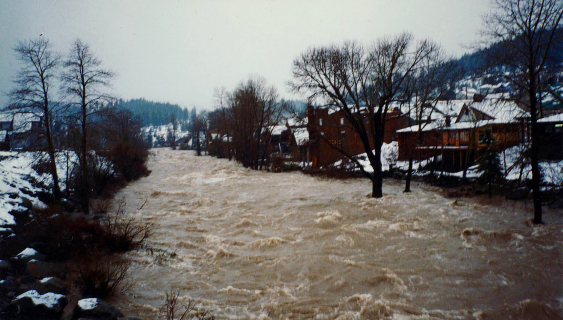
Several of the creek’s culverts restricted flood flows and increased flood hazard in downtown Truckee. January 1997 recorded a significant flood event in downtown Truckee. Another ‘rain-on-snow’ event occurred in 2006. Flooding is most severe in saturated ground conditions, when the ground is frozen and infiltration is minimal or when runoff from heavy rain is augmented by melting snow.
Truckee knew it needed to do something. In 2002 and again in 2008 studies were done to assess how to manage the creek. The Town of Truckee, Truckee River Watershed Council and Truckee Development Associates worked together on a multi-objective redevelopment project to revitalize the downtown area and the adjacent railyard, reduce flood risks for downtown businesses and residents and improve the natural and aesthetic qualities of lower Trout Creek. This work is ongoing and Trout Creek is slowly being restored to ‘close’ to what it was.
Judy DePuy is a member of Truckee-Donner Historical Society and on the board for the Truckee Donner Railroad Society and Museum of Truckee History. She resides in Tahoe Donner with her husband, Dave, and their dog, Morticia
HCS 6/26/2021


